SATELLITE IMAGES OF THE KNOWN ISLANDS

Euro-American Island in 2003, as seen from airplane

Presently there are 6 known “visited” islands located north of Khaffeklubben Island, which have been identified and visited on foot. They are all within a range of 5 miles of the coast of Greenland.
The first island to be spotted and visited was Odaq in 1978. The next island to be visited was the Top of the World Island, in 1996. It is slightly farther north than Odaq Island.
Top of the World Island can be found at the left side of this 2005 enhanced satellite image, within a cluster of gravel bars. These gravel bars are spread out over a distance of 200 meters.
The KMS Island found in 1997 is located south west of the Top of the World Island. It can be seen here in this satellite image. Dupree Island was discovered in 2000 is located in the southwestern corner of this cluster.

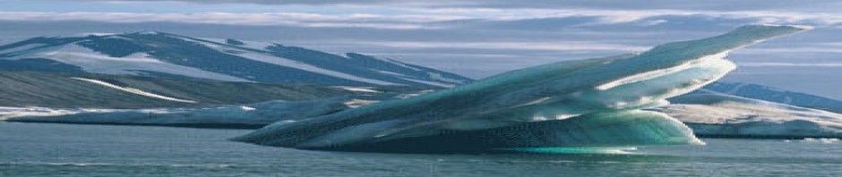
Euro-American Island, when first photographed in 1998
The Euro-American Island, discovered in 1998 and visited in 2003 lies quite a distance north of the Top of the World Island. It can be seen here in photograph taken from an aircraft in 2003.
The “Known Islands” can be identified as follows:
1) The ATOW (Top of the World) 1996 Island is located in a cluster of gravel bars that is spread out over a distance of 200 meters
2) Odaq Island, which appears to be flooded or partly covered with snowdrifts
3) KMS 1997 Island can be seen southeast of the ATOW 1996 Island
4) The Dupree 2000 Island is located in the Southeast edge of the cluster
5) Euro-American island, first spotted in 1998 by Dr. Skafte, and first visited in 2003
.
“In 1998 I was on aerial reconnaissance north of Kaffeklubben Island. After passing Top of the World Island, I was looking several miles to the north, and for a few seconds I spotted an island. No one else saw the island at that time because they were all photographing out the other side of the plane, looking south toward the Greenland coast. This is the moment when the Euro-American Island was discovered. I did not tell anyone, except my close friends, about the island until 2003, when an expedition was organized and we managed to find the island after 10 hours trekking across the sea-ice. It is presently the northernmost visited island.”
–Dr. Peter Skafte
Most recently visited of the “Known” Islands

In 2005 Dr. Peter Skafte, Allen DeForest and Paul Lommen identified several new islands utilizing satellite imagery. One of these islands was named Skafte Island and posted on the Arctic Thule website as seen above on the right. Dr. Skafte showed the image of the island to an organizer of an expedition to the north coast of Greenland, who visited the island in 2007.
Turtle Island, seen in the photo at right, has only been seen once in 2005, and has not been seen again or confirmed.
Although Skafte Island is thus far the most recently visited location in the known islands, Dr. Skafte has identified other islands that are farther north, and these will be explored during the next Arctic Thule expedition.